Sunday, June 30, 2013

El Salvador

El Salvadore's fertile cropping lands

In the bright afternoon light I briefly headed southwards into El Salvador before turning inland where a steadily climbing, rocky trail took me initially through small villages and cropping land and then through increasingly forested hills until eventually I arrived at Parque Nacionale El Imposible where, fortunately, it was “posible” to camp. With the calls of birds cascading from the forests above, and the laughter of children drifting up from the villages below, I set up camp once again. As darkness descended the sounds of men and beasts gave way to the rumbling of thunder and flashing of lightning across the mountains as the predictable wet-season storms rolled in bringing refreshing showers and cooling breezes. A  dance in the rain provided my shower before settling into the cozy comfort of the van with a Chilean red wine and the rain pattering steadily on the  roof.

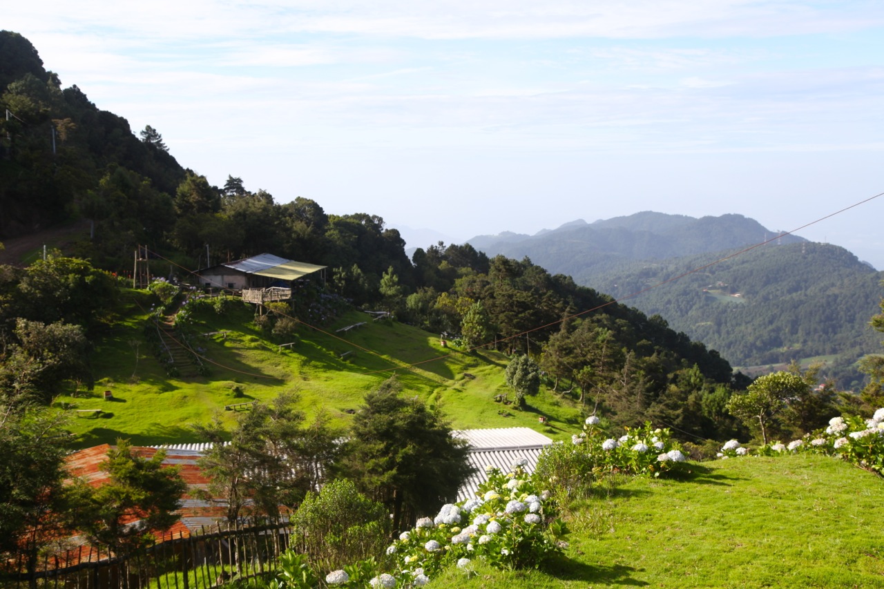
The luxuriant cloud-forests of El Iposible
The next couple of days were spent exploring the trails of El Imposible, firstly with my guia, Albierto, who has spent 30 years in this park - he knows it pretty well! The trail that we took gave us great views across the valleys to jungle-shrouded mountain slopes to the south and east before descending steeply to a beautiful stream that cascaded over a series of small falls interspersed with enticing, crystal clear pools. While the birds were not very cooperative, teasing us with their calls yet remaining elusive in the thick forest, we did find a small snake and catch a glimpse of a small tail-less mammal (an agouti I’d guess) that scurried through the undergrowth.  A delightful morning with broken spanish for communication, in a stunning tropical forest.


After that, I explored the other trails on my own, including a night walk that revealed nothing more than a kinkajou, but it was magic, standing quietly in the middle of the jungle with the light turned off, listening to the noises of the forest with not another soul within miles.


From El Imposible,  it was a relatively short trip to the nearby park of Cerro Verde, with a brief stop at a roadside tienda to stock up on vegies (and beer). A little bit of a wait as the lady quickly cooked me some fresh tortillas.

My campsite was in the parking lot of the park with views over the classically conical Volcán Izalco one of the youngest of the various volcanoes in the region. This volcano has reminded locals of its presence at regular intervals through the 20th century. Above me, shrouded in brooding clouds was the higher Santa Ana or Ilamatepec which is also only snoozing, having erupted as recently as 2005. 

Volcán Izalco


Firstly, I tackled the rocky slopes of Izalco with a group of half a dozen younger San Salvadorean guys, and was encouraged to see that I was in better shape than these guys 30 years younger than this viejo (old fart). A novel aspect of the climb was being accompanied by 2 armed policemen - never hiked with someone riding shotgun before! 


The next day was a longer but less steep climb up Ilamatepec which, while less classical from the outside, had a crater at the top with all of the spectacle and drama that one expects from any self-respecting volcano. The swirling clouds with brief flashes of sunshine added to the drama but as thunder and lightning started to build we scrambled back down, arriving back at camp as the rain started. Together with a few other hikers we piled into the van for a hot coffee before the others headed off on their bus and motorcycle respectively.

Atop Llamatapec


View over Lago Coatapeque
A brief descent took me to nearby Lago Coatapeque. I was thinking that I would find a comfy hotel for a change, but it turns out that the lake-front is owned by wealthy El Salvadorians and, as you drive around it, you effectively drive behind big concrete walls that prevent anyone else from enjoying the spectacular views that the lake offers. Fortunately, virtually at the end of the road there was an area for community access where I was able to find a very pleasant campsite - after declining the prison-cell-like “habitationes” that they offered. On the edge of a stunning volcanic crater lake, the rooms had no windows, and the two uncomfortable looking beds took up almost all of the floor space! Instead, I suggested that I might be able to park my van on a nice flat spot with views across the lake which they agreed to, for a fee of $4. In response to my question about whether they sold beer, they said no, but they would go and buy some for me and deliver it to my van, so 15 minutes later, as the light faded, my beer was delivered and I was comfortably ensconced in my cosy cocoon when the rain started yet again and the surprisingly comforting sound of thunder rolled across the lake. 

On the shores of Lago Coatapeque

My treat for the following morning was the discovery of pupusas.  Like me, it seems that El Salvadorians have acknowledged that tortillas are actually not very interesting and that, if you fold beans, cheese and/or green vegetables into them, they get a lot tastier - yum! Normally I wouldn’t eat at a “restaurant” that has no other guests, but on this occasion it was obvious that I was just sharing breakfast with the very friendly family that looked after the place and there was nothing in the ingredients that was likely to go  off. 

El Salvador is the smallest of the central American countries,so it doesn’t take long to get around, even going as slow as I am, so I set off towards La Palma, near the Honduran border, but a sign to Suchitoto on a side road tempted me and I diverted to this little pueblo known for its arts scene on the weekends. There’s no denying that it is a very pleasant little town, but I guess I have been spoiled by the cultural richness of Mexico and the mountain villages of Guatemala. Mind you, it is mid-week and the place may come to life on the weekend, but it was pretty sleepy today. Maybe one also has to reflect on the impact of the awful history of this country, with the active discrimination against, and even extermination of, indigenous communities and the loss of cultural heritage that goes with it. Many of the El Salvadorian towns are practical, semi-functional service centers and you get the feeling that places like Suchitoto represent an attempt to rebuild and recapture some of that tradition rather than being a natural consequence of a slowly evolving heritage. One can only admire the resilience of these people after what they have lived through!

La Palma, my next stop, sat in the cool ranges that bordered Honduras. Hotel La Palma’s parking lot provided a great place to spend a couple of nights - nice restaurant overlooking the river, very friendly owner (all of his family had moved to Australia), wifi, and close proximity to a great pupusaria to offset the more pricey hotel restaurant. 


Folk art on the streets of La Palma
The highlight of this little pueblo is the simple and colorful street art that captures the daily aspects of life and the environment of El Salvador. It seems that much of this style is attributable to Fernando Llort Choussy who tought and inspired local people to try to make a living through art. 


La Palma happens to sit at the bottom of El Salvador’s highest mountain, El Pital, the peak of which is shared with Honduras. A very steep road, which turns into an even steeper and rougher track, takes you to within a short walk of the top. A small flat area provided my campsite for two nights with great views over the valleys below. While there is virtually no view from the top of  El Pital itself (too much vegetation!) a sendero (trail) through beautiful cloud forest takes you to a lookout that has to be reached by crossing a crevice on a fallen tree trunk with only a single cable for balance.
Near the top of El Pital

My descent from El Pital was momentarily halted by a car stuck in a ditch and blocking the road. They were tourists from San Salvador out for the weekend and had no idea how to get themselves out of their difficulties.  For the fourth time my rescue gear came in handy, (fortunately on all occasions rescuing someone else) and I quickly winched them out which probably saved them from a cold wet night on the mountain, as I don’t think they were going to get themselves out. 

Another night in the parking lot of Hotel La Palma in preparation for the border with Honduras. Woke up with a very unsettled stomach. Obviously something I had eaten did not agree with me - probably the not-quite-ripe fruit that I bought from some young kids on the roadside. After getting most of it out of the system, I set off for another dreaded border crossing .... and by all accounts Honduras has the worst crossings. With an unpredictable stomach, I was not looking forward to it and was hoping that I would be accosted by touts who would help me through the process, but no such luck - not a one to be seen. So again, I drove past all of the trucks and then managed a fairly straightforward, albeit time consuming process. It was slowed down by the fact that my timing coincided with lunch, so the banks where I had to pay for my vehicle import permit, and the photo-copy shops where I had to get the the dozens of photocopies, were all closed, turning what would have been an hour and a half crossing turned into two and a half. 

But my stomach held out and finally I was on my way into Honduras.

Saturday, June 22, 2013

Gorgeous Guatemala


A very civilized border crossing with the help of a young guy who probably wasn’t really necessary but who, by taking me from one counter to the next reduced the need for me to ask the obvious questions. My first destination was Tikal, only a short distance into Guatemala. A brief stop at a tiny roadside tienda for some eggs and some (very limited) vegetables took the locals by surprise but at least I had the makings of a meal for tonight if nothing else eventuated. The drive to Tikal took me around the edge of Lago de Petén and into impressive forests until, at the entrance to the ruins I found a very pleasant campground with the usual dysfunctional toilets and showers - but the location, on the edge of the ruins was perfect. Ocellated turkeys and various furry things scurried around the campsite.

Crap! What’s that?! Oh - the alarm. The what??? Yes - the alarm! What the...! Last time I heard one of those was in a fading nightmare called “work”. But sure enough, it’s 4 am and I’m scheduled to visit the Tikal pyramids for sunrise. The fact that its raining is not encouraging and I’m tempted to roll over, but I have a guide organised, so a quick coffee and I’m off through the forests at a brisk pace in order to climb temple IV as the sun battles with storm clouds on the eastern horizon. It’s fair to say that the sun lost, but it put up a valiant battle and cast intermittent swards of light across the landscape as we gazed over the remarkable ruins of Tikal - temples towering above the jungle, with toucans sweeping from tree to tree and the roar of howler monkeys providing the soundscape. OK, so that’s not a bad reason to be woken up by an alarm! 


Sunrise over Tikal
An aracari - you guessed it, one of the toucan family
The rest of the morning was spent exploring the remarkable remnants of this once great civilisation, and in the evening a walk through some more remote forest trails revealed lots of new birds. And then the clouds burst again, forcing me to retreat into some nearby ruins, fortunately with smoke-lined tunnels that enabled me to get in from the rain - shelter that I shared with bats and swallows as the light faded. A little later, he jabbering of spider monkeys heralded the end of the downpour, enabling me to make my way back to camp as darkness fell.


From Tikal, another relatively short drive took me to the little town of Flores nestled on a very pretty little island that floats off the shore of Lago (Lake) Petén Itzá. Half an hour would be sufficient to walk around it, but the numerous colorful cafes and restaurants are quiet enticing, so it ends up taking more like 2 hours. The consequence of this was that I was on the road to my next intended destination a little later than intended, and the roads, the ferry crossings and the gorgeous countryside not to mention (again) the dreaded topes, which have now changed their name to “tumulos” (but retain their impact on suspension) are not conducive to rushing.


As you head south from the lake, the flat lands start to undulate and the amount of vegetative cover increases (although all of it is second growth) until a row of limestone mountains looms ahead like a barrier. The dark cluds are building overhead, but the low evening sun sneaks through every now and then, lighting up a landscape of scattered fields and scattered villages. The houses here are simple, but charming (to someone who doesn’t have to live in them) - wooden slat walls with thatch roofs. In the sultry evening everyone is out on the streets. The women are all dressed in long, patterned, pleated skirts with a light, filamentous shawl over tops that seem not much more than lingerie -  very practical given the humid conditions. The older men wear their cowboy hats and the young guys - yep - you guessed it - all wear baseball caps.

The sun is starting to drop by now and it is clear that I’m nowhere near where I intended to be by the end of today, so I’ve  pulled down a gravel side road with a sign for a “Balnerio” or water park to find a beautiful little glade tucked in among the jungle-clad limestone ridges alongside a stream that emerged from a cave. The caretaker has told me that I can camp for the night - altho his price (by local standards) is ridiculous) but given the hour I’m not going to argue - and it is very nice. A pre-dinner swim and fire-flies yet again ended a very pleasant day. 

A beautiful day’s drive took me through the limestone ranges, although their attire of rainforest was severely fraying around the edges as farmers made incursions into ever more questionable farming land - planting crops on steep slopes that presumably are going to wash away with the first major downpour. I assume they hope that they can get a crop off before this happens. 

My route didn’t go quite as planned as my questioning about the way to Coban didn’t take into account the possibility that there were two routes - consequently my GPS showed me traveling across country where there was no road when in fact the one that I was on was obviously real and, in fact, was very good. The prohibitive price of gas for the locals also meant that there was not much traffic on the road apart from a few trucks and a regular but light stream of mini-buses which, reassuringly, all had Coban,as one of the two town names between which they plied their trade, on the front. 


Covered fern plantations - unfortunately they clear forest to grow them.
Consequently I missed out on my intended destination of Lanquin and found myself coming into the higgledy-piggledy ridge-top town on Coban via the backdoor. Obviously main roads didn’t exist when the town was built so, while various major roads lead into the town they then get redirected in various directions with no signs indicating how to get out, so you meander through ever-narrowing lanes, reversing out of unsigned one way streets until, after numerous preguntas (questions) you finally pop out the other side on what seems to be the correct road. Another hour or so’s driving brought me through a steep sided valley to the Quetzal Biotope. You have to like a country that names its currency after its iconic bird. Imagine calling the Australian currency the Kookaburra - hmmm...that could work! 

After spending the first day wondering around the higher forest ridges in an unsuccessful search for quetzals, I heard that the best place to see them was in the garden of an adjoining little guest house, so I moved in there and, sure enough, over the next two morning got some great sightings, their colors flashing blue and green as they displayed in the morning sun.


Lousy picture but it is a quetzal!

After a "pankake" breakfast I hit the road, this time heading towards Huehuetanango. For the first couple of hours, the road was terrible and I ground slowly up hill and down dale, through steep sided valleys where excessive clearing on precarious mountainsides had resulted in many landslips and in one place, a massive landslide which, judging by the shrine with many names on in, must have taken a bus or a village with it. A massive afternoon downpour made driving impossible for an hour or so, but after waiting for it to pass, I made my way up a side road to the town of Nabaj - a medium sized town set in the mountains. A local balnario (water park) provided my accommodation for the night where I parked on the basketball court, adjacent to the paddling pools. People are incredibly helpful and accommodating and don’t seem to think anything of some crazy gringo rocking up and wanting a place to spend the night in his crazy car with a boat on the roof!


I'm guessing that the wet season may have arrived!

After breakfast and coffee by the swimming pools, I cycled into the centre of town where the markets were already in full swing. Navigated my way through the seething throngs of good-natured market goers. It’s easy to get a smile here and generally people are happy to have their photo taken, which is great given how colorful their attire is. A bit more cycling took me through the backstreets and into the surrounding countryside with a brief stop to watch a bit of local futbol, but unfortunately the standard wasn’t particularly high. 


From Nabaj, I made my way towards Lago de Atitlan, a drive through largely cleared mountains but looking incredibly verdant as the scattered villages almost appeared to be sinking into the rapidly growing corn - an idyllic landscape at this time of year if you don’t look at it with the eyes of an ecologist. Again the afternoon clouds engulfed the mountains and it was only after a steep descent from Solala that I emerged to be confronted with the spectacular Lago de Atitlan, fringed by forest, steep cliffs and three volcanic peaks. A hotel by the waterfront had no guests, but did have spectacular views over the lake, and an area for camping, so I found myself with a million dollar view for what was a pricy 150 Quetzales ($15) but what the heck, this is said to be one of the most beautiful lakes in the world and I'm not arguing.


My next destination was the ancient city of Anigua Guatemala, once the capital of the country but a devastating earthquake laid much of it to waste and the capital was relocated. Antigua however has rebuilt itself as a very pleasant little cultural capital, with lots of nice cafes and restaurants and stunning views to the mountains and volcanoes that surround it.


Cultural contrast!

The smoking Volcano Pacaya was my next destination where a local "guide" offered to take me up the back way, so we proceeded to poke along back roads through little villages until we were confronted by the lava and scree slopes of the volcano. Some low range 4x4 crawling took us further up the mountain (I’m impressed by what this truck can do) until we could go no further, after which we scrambled upwards on foot over the loose black, honeycomb textured rocks which gave way under our feet, sending rocks tumbling down the slopes below. Clearly this was a very young landscape, with a few lichens and plants taking the first steps towards what would, if left to its own devices, ultimately become a jungle-clad slope if only we humans were to let nature take its course, which is highly unlikely to happen.  


After scrambing around on the slopes, with smoke belching above and the occasional rumble from the volcano we headed back down to explore more little villages and a nearby lake before I set off westwards to once again reacquaint myself with the not very peaceful Pacific. On this occasion, the large dumping waves crashed on the black sand beach of Monterico, Guatemala’s attempt at a beach resort strip - all very low key with only a few visitors around to support way too many restaurants and hotels. I had decided to stay in a hotel here, thinking to indulge, but the place I stayed, supposedly one of the more popular with over-landers, had way more staff than guests. Passed a pleasant evening chatting with Tony, an Irish/Scotsman who had spent the last 20 years in Guatemala and was helping to manage this hotel, alternating between Lago de Amatlan and Monterico. He mad the interesting observation that even paradise becomes boring if you are there too long and, as a consequence he was looking to move on - an interesting observation given how enticing somewhere like Guatemala could be to anyone looking for a new place to spend some time. 

I decided to take the back way out of Monterico to get to the San Salvador border but the road just took me to the edge of a mangrove-lined river. So, what do you suspect they use barges like this for?


Obviously to overload with vehicles! But, the locals seemed to think it was safe so.....


...with much creaking and groaning I inched aboard.


I thought that I was just crossing the river but the next thing I knew we were heading inland through the mangroves, hoping fervently that the destination was close enough to be reached before the rapidly inflowing water became a problem!  


After about two kilometers we finally came ashore, where I inched off once again to the sound of splitting timbers and waved goodbye to the boatmen as they bailed out the water, and farewell to Guatemala as, shortly afterwards I crossed into El Salvador. 

I'm not sure why Guatemala had never found its way on to my radar before, but it is truly an amazing country - one which I will happily return to.